MegaPlat
Use this class to plat land across any number of townships, with all townships appearing on the same page.
The three methods for adding lands to the MegaPlat are:
.add_description(), for adding the full text of a land description.
.add_tract(), for adding apytrs.Tract(already parsed).
.add_tracts(), for adding multiplepytrs.Tractobjects (already parsed), such aspytrs.PLSSDescorpytrs.TractListobjects, which contain tracts.
See
LotDefiner
for how to work with the .lot_definer attribute.
See
Settings
for how to work with the .settings attribute.
See this discussion on working with multiple layers for using multiple colors for different tracts.
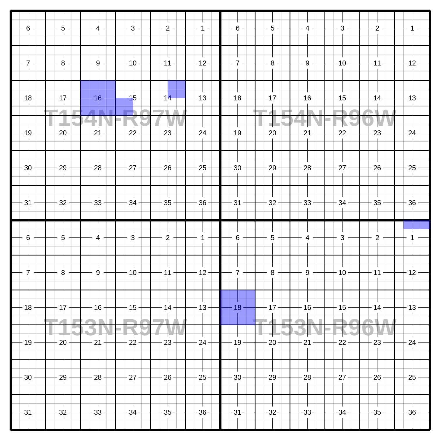
Example Image
(Resized from original output. Click to see full size.)
Example Code
This results in the image above.
import pytrs
import pytrsplat

# Choose a settings preset.
mp_preset = pytrsplat.Settings.preset('megaplat_default')
# Adjust settings as desired.
mp_preset.set_font('header', typeface='Sans-Serif (Bold)', size=80)

megaplat = pytrsplat.MegaPlat(settings=mp_preset)
# If we've written lot definitions to .csv, we load them here.
megaplat.lot_definer.read_csv('some_lot_definitions.csv')
# Otherwise / additionally, we can assume 'default' lots.
megaplat.lot_definer.allow_defaults = True
megaplat.lot_definer.standard_lot_size = 40

# Add lands with `.add_description(), `.add_tract()`, or `.add_tracts()`.

land_desc = """T154N-R97W
Sec 14: NE/4
T153N-R96W
Sec 1: Lots 1 - 3
Sec 18: ALL"""
# `config` gets passed to pytrs for parsing.
megaplat.add_description(
    land_desc,
    config='n,w'    # Optional, control parsing of description.
)

tract = pytrs.Tract(
    desc='SW/4',
    trs='154n97w15',
    parse_qq=True,  # parse_qq=True is REQUIRED
    config='n,w'    # Optional, control parsing of description.
)
megaplat.add_tract(tract)

plss_desc = pytrs.PLSSDesc(
    'T154N-R97W Sec 16: ALL',
    parse_qq=True,  # parse_qq=True is REQUIRED
    config='n,w'    # Optional, control parsing of description.
)
megaplat.add_tracts(plss_desc)

# Executing the queue will fill in the plat.
megaplat.execute_queue()

# Save to PNG.
megaplat.output(fp=r'some\path\megaplat 153n96w-154n97w.png')
# or to PDF (or nearly any other image format)
megaplat.output(fp=r'some\path\megaplat 153n96w-154n97w.pdf')
# or as PNG image inside a zip file.
megaplat.output(fp=r'some\path\megaplat 153n96w-154n97w.zip', image_format='png')
Methods and Attributes
- class pytrsplat.MegaPlat(settings: Settings = None, lot_definer: LotDefiner = None, max_dim: tuple[int, int] = None)
A dynamic plat showing multiple townships on the same page.
Does not allow for footers, and ‘headers’ are instead written at the center of each township. Consider using a
.headerfont_rgbain the settings that is faint, to avoid obfuscating section lines, etc.Warning
The dimensions of a
MegaPlatoutput are determined by the number and spread of the townships in the tracts added to the queue. The resulting images can probably be extremely large. As a safeguard, specifymax_dim=(int, int)as a limit to the dimensions you are willing to generate. If either of those dimensions is violated, it will raise aRuntimeError.Note
The size of each component plat (one for each township) is controlled by
.sec_length_px. And.body_marg_top_yserves as the margins on all four sides of the resulting group of plats.Note
This will not allow Townships in the queue to be both North and South (i.e.,
'154n'and'27s'cannot coexist in the queue). Similarly, Ranges may not be both East and West ('97w'and'58e'cannot coexist). If either condition is violated, aValueErrorwill be raised.- __init__(settings: Settings = None, lot_definer: LotDefiner = None, max_dim: tuple[int, int] = None)
- Parameters:
settings – The
Settingsobject to control the behavior and appearance of this plat.lot_definer – A
LotDefinerobject to use for defining lots in tracts that are added to the queue. (Can also be modified or replaced in the.lot_definerattribute later.)max_dim – (Optional) Specify the largest dimensions that may be generated. If exceeded, a
RuntimeErrorwill be raised prior to plat generation.
- add_description(txt: str, config: str = None, layer: str = None) TractList
Parse the land description and add the resulting tracts to the plat group. If one or more Twp/Rge’s are newly identified, plats will be created as needed.
- Parameters:
txt – The land description.
config – The config parameters for parsing, to be passed through to the
pytrslibrary. (See pyTRS documentation for details.)layer – Name of the layer to add this description to.
- Returns:
A
pytrs.TractListcontaining the tracts in which the parser could not identify any lots or aliquots.
- add_tract(tract: Tract, layer: str = None)
Add a tract to the queue.
Note
The tract must already be parsed for lots/QQs. (See
pyTRSdocumentation for details.)- Parameters:
tract –
pytrs.Tractto add to the queue.layer – Name of the layer to add these tracts to.
- add_tracts(tracts: list[Tract] | TractList | PLSSDesc, layer=None) None
Add multiple tracts to the queue.
Note
The tracts must already be parsed for lots/QQs. (See
pyTRSdocumentation for details.)- Parameters:
tracts – A collection of
pytrs.Tractobjects, such as apytrs.PLSSDesc,pytrs.TractList, or any other iterable object that contains exclusivelypytrs.Tract.layer – Name of the layer to add these tracts to.
- carve_description(txt: str, config: str = None, layer: str = None) TractList
Parse the land description and carve out the resulting tracts from the queue, so that they do not appear on the resulting plat.
(Affects only which lands get filled in on the plat. This carve-out will NOT prevent tracts from being written to the footer, if so configured.)
Note
All carve-outs override the queue for a given layer. In other words, when the queue is executed, all added lands will be platted for that layer, then all carved-out lands will be removed from that layer. This means that carved-out lands cannot be re-added to the queue for that same layer. They can be added to the queue for a different layer.
Carve-outs for any given layer can be cleared with
.clear_layer_carveouts(layer=<name>).Warning
Any lots or aliquots identified in this description will be removed from the layer. Be careful to use a ‘clean’ description that will not remove lands that should be kept.
- Parameters:
txt – The land description.
config – The config parameters for parsing, to be passed through to the
pytrslibrary. (See pyTRS documentation for details.)layer – Name of the layer to carve this description from.
- Returns:
A
pytrs.TractListcontaining the tracts in which the parser could NOT identify any lots or aliquots.
- carve_tract(tract: Tract, layer: str = None) None
Carve out lands (single tract) from the queue, so that they do not appear on the resulting plat.
(Affects only which lands get filled in on the plat. This carve-out will NOT prevent tracts from being written to the footer, if so configured.)
Note
The tract must already be parsed for lots/QQs. (See
pyTRSdocumentation for details.)Note
All carve-outs override the queue for a given layer. In other words, when the queue is executed, all added lands will be platted for that layer, then all carved-out lands will be removed from that layer. This means that carved-out lands cannot be re-added to the queue for that same layer. They can be added to the queue for a different layer.
Carve-outs for any given layer can be cleared with
.clear_layer_carveouts(layer=<name>).Warning
Any lots or aliquots identified in this tract will be removed from the layer. Be careful to use a ‘clean’ description that will not remove lands that should be kept.
- Parameters:
tract – A
pytrs.Tractthat has been parsed into Lots and QQ’s. (Its Twp/Rge must match what is already in the queue.)layer – Name of the layer to carve this tract from.
- carve_tracts(tracts: list[Tract] | TractList | PLSSDesc, layer: str = None) None
Carve out lands (multiple tracts) from the plat, so that they do not appear on the resulting plat.
(Affects only which lands get filled in on the plat. This carve-out will NOT prevent tracts from being written to the footer, if so configured.)
Note
The tracts must already be parsed for lots/QQs. (See
pyTRSdocumentation for details.)Note
All carve-outs override the queue for a given layer. In other words, when the queue is executed, all added lands will be platted for that layer, then all carved-out lands will be removed from that layer. This means that carved-out lands cannot be re-added to the queue for that same layer. They can be added to the queue for a different layer.
Carve-outs for any given layer can be cleared with
.clear_layer_carveouts(layer=<name>).Warning
Any lots or aliquots identified in these tracts will be removed from the layer. Be careful to use ‘clean’ descriptions that will not remove lands that should be kept.
- Parameters:
tracts – A collection of
pytrs.Tractobjects, such as apytrs.PLSSDesc,pytrs.TractList, or any other iterable object that contains exclusivelypytrs.Tract.layer – Name of the layer to carve these tracts from.
- clear_layer_carveouts(layer: str = None)
Clear the carve-outs for the specified
'layer'.- Parameters:
layer – Name of the layer to clear the carve-outs for.
- clear_layer_queue(layer: str = None, include_carveouts=False)
Clear the contents of the queue for the specified
'layer'.- Parameters:
layer – Name of the layer to clear the queue for.
include_carveouts – (Optional) Also clear any carve-outs for this layer.
- execute_queue(subset_twprges: list[str] = None, prompt_define=False) TractList
Execute the queue of tracts, and generate the plat.
- Parameters:
subset_twprges – (Optional) Limit the generated images to this list of Twp/Rges (in the pyTRS format – e.g.,
['154n97w', '155n97w']).prompt_define – (Optional) If
True, first check for undefined lots, and prompt the user in console to define them.
- Returns:
A
pytrs.TractListcontaining all tracts that could not be platted.
- find_undefined_lots(allow_defaults: bool = None, fp: str | Path = None, **headers) dict[str, list[str]]
Find all tracts in the queue that have one or more lots that have not been defined. Optionally write them to a .csv file at path
fp, to facilitate defining them externally.Warning
If passing
fp, any file at that path will be overwritten without warning.- Parameters:
allow_defaults – Whether to assume that all sections are ‘standard’, with typical lots (if any) in sections along the north and west township boundaries. If not specified here, will use whatever is configured in the
lot_definer.allow_defaultsattribute.fp – (Optional) A filepath at which to create a .csv file containing the undefined lots.
headers – (Optional) If saving the undefined lots to a .csv file, pass keyword arguments to specify the desired headers. (Reference the docs for
LotDefiner.save_to_csv()for the appropriate parameters.)
- Returns:
A dict, keyed by Twp/Rge/Sec (
'154n97w01'), whose values are a sorted list of lots for that Twp/Rge/Sec.
- find_unplattable_tracts(allow_defaults: bool = None) TractList
Get a
pytrs.TractListcontaining all tracts that cannot be platted with the currently provided lot definitions (optionally accounting for default lots, if so configured).Note
If a tract has any aliquots and/or any lots that have been defined, it will be considered plattable, even if some of its lots have NOT been defined. To check for undefined lots, use the
.find_undefined_lots()method.- Parameters:
allow_defaults – Whether to assume that all sections are ‘standard’, with typical lots (if any) in sections along the north and west township boundaries. If not specified here, will use whatever is configured in the
lot_definer.allow_defaultsattribute.
- output(fp: str | Path = None, image_format: str = None, layers: list[str] = None, image_mode: str = 'RGB', **_kw) Image | None
Compile and return the merged image of the plat. Optionally save the results to disk, either as an image or as a .zip file containing the image.
- Parameters:
fp – (Optional) If provided, save the output to the specified filepath.
image_format – (Optional) Override the image format of the file specified in
fp. If not provided, will defer to the file extension infp. (Only relevant if saving to file.)layers – (Optional) Choose which image layers (in bottom-up order) to include in the output. (See
Plat.DEFAULT_LAYER_NAMESfor the standard layer names.) Nonexistent or empty layers will be ignored. Any custom layers created by.add_description(..., layer=<name>)(and similar methods) will be included by default, unless thelayers=parameter is used here.image_mode – Specify which image mode to convert the merged output to. Defaults to
'RGB'. (ReferencePIL.Image.Image.convert()for further details.)_kw – No effect. (Included to mirror
.output()of other classes.)
- Returns:
The generated image. If no layers have been configured and/or
layerscontains only layers that are nonexistent or empty, will returnNoneinstead.
- prompt_define(allow_defaults: bool = None)
Prompt the user in console to define all lots that have not yet been defined for tracts in the queue. Any new lot definitions will be added to the
.lot_definer.(You may wish to save the results with
.lot_definer.save_to_csv()so that they can be loaded and reused later.)- Parameters:
allow_defaults – Whether to assume that this section is ‘standard’, with typical lots (if any) in sections along the north and west township boundaries. If not specified here, will use whatever is configured in the
.lot_definer.allow_defaultsattribute.
- write_lot_numbers(at_depth=2, only_for_queue: bool = None)
Write the lot numbers to the MegaPlat.
Note
Lot numbers will only be written for the Twp/Rge’s that were last processed with
.execute_queue().- Parameters:
at_depth – Depth at which to write the lots. Default is 2 (i.e., quarter-quarters).
only_for_queue – (Optional) If
True, only write section numbers for those sections that appear in the queue.